Posted: Mon Oct 07, 2013 5:43 pm
Post subject: Map of Poland about 1910 & as the shape changed
Posted: Mon Oct 07, 2013 5:43 pm
Post subject: Map of Poland about 1910 & as the shape changed
Hello
I am looking for a map of Poland as I guess Prussia had some of it about 1910. Antoni Kaczmarczyk was born in Poland 1882, but his picture shows him in a Prussian uniform about 1910. He lived in the south of Poland, southwest of Krokow, near the Chec border.
My question is was that part of Prussia at that time? Also does anyone home maps of Poland as it changed during the years.
I have been told that Russia, Germany & Ukraine also had part of Poland at times.
I have the picture of Antoni Kaczmarczyk on the Forum. Please have a look at it.
Diane Potter
|
|
|
dnowickiPO Top Contributor
Joined: 28 Dec 2011
Replies: 2950
Location: Michigan City, IndianaBack to top |
Posted: Mon Oct 07, 2013 7:21 pm
Post subject: Poland in 1910
Diane,
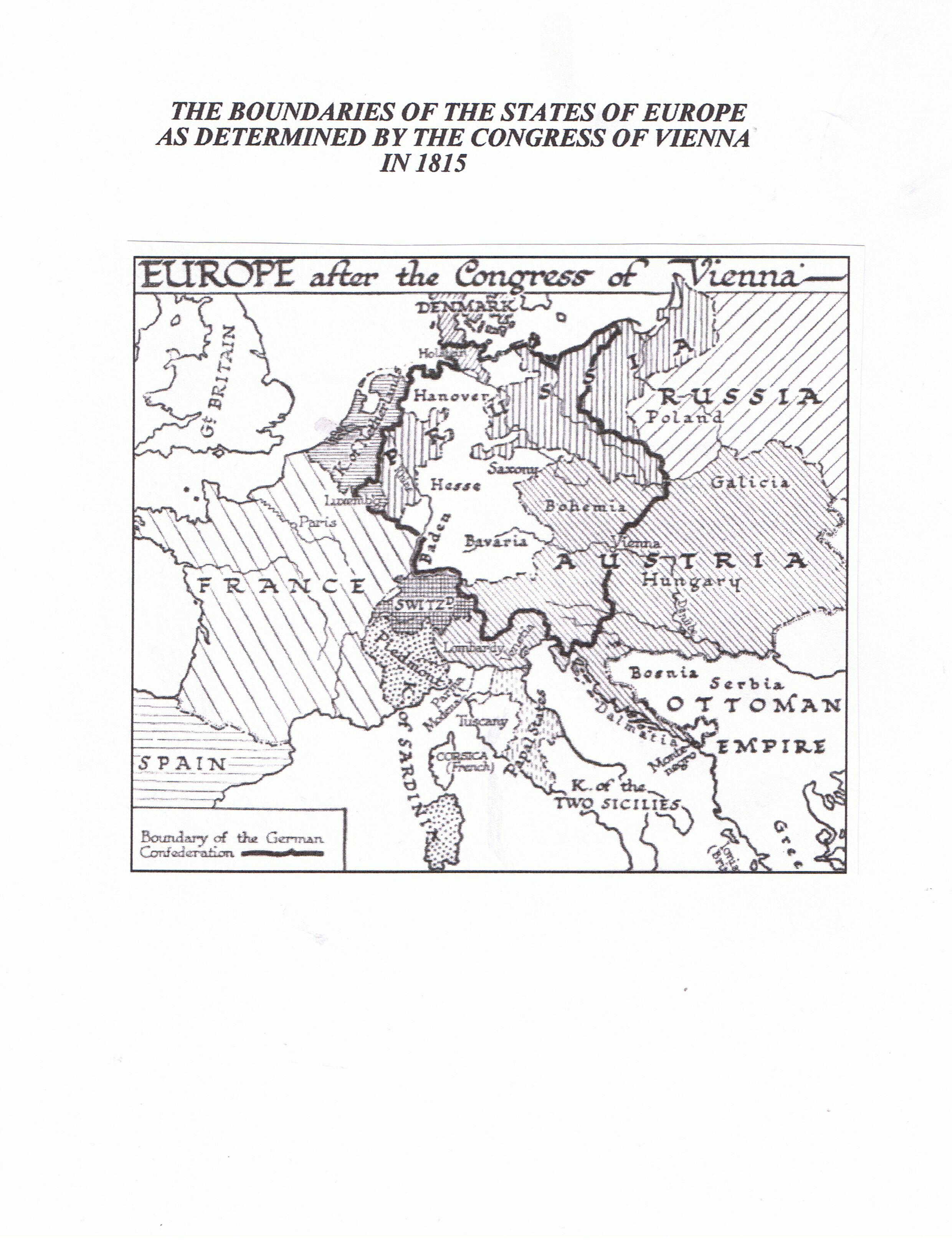
There really is no map of Poland in 1910 because it did not exist as an independent political entity from 1795 until after World War !. There are maps which show Poland or the so called Congress Kingdom of Poland but that was an entity set up by the Congress of Vienna in 1815 and was ruled by Russia and thus was often referred to as Russian Poland. I will post some maps which help in the visualization of the stages of the process by which Poland ceased to exist as an independent state between 1772 and 1795. The first post is a map of the Commonwealth of Poland also called the Republic of the Two Nations as it existed in the XVI Century as it began to lose some of its territory. The next two maps show how Poland shrank as it lost territory as a result of the first and second partitions. The fourth map shows the complete dismemberment of Poland after the third partition in 1795. The fifth map shows the states of Europe with their borders as determined by the Congress of Vienna in 1815. Poland on this map refers to Russian Poland. The sixth map shows the Congress Kingdom of Poland (Russian Poland) and the area to the southwest of the Congress Kingdom shows some former Polish territory which was under the control of Prussia/Germany until after World War I.
Please ignore references to ancestors as these maps were put together for the benefit of my siblings, nephews, nieces, cousins, etc.
Hope the maps help a bit.
Dave
| Description: |
|
| Filesize: |
831.96 KB |
| Viewed: |
14399 Time(s) |
|
| Description: |
|
| Filesize: |
809.11 KB |
| Viewed: |
14399 Time(s) |

|
| Description: |
|
| Filesize: |
959.65 KB |
| Viewed: |
14399 Time(s) |

|
| Description: |
|
| Filesize: |
937.24 KB |
| Viewed: |
14399 Time(s) |

|
| Description: |
|
| Filesize: |
969.26 KB |
| Viewed: |
14399 Time(s) |

|
|
|
|
Posted: Tue Oct 08, 2013 10:50 am
Post subject: To dnowicki
Thank you very much for the maps. Now I can see why Antoni Kaczmarcyk was in a Prussian uniform.
Thank heavens Poland is or almost back to normal again.
They have come along way even since WW11 and comunist left.
Diane Potter 
|
|
|
Elzbieta PorteneuvePO Top Contributor
Joined: 09 Nov 2012
Replies: 3098
Location: Paris, FranceBack to top |
Posted: Tue Oct 08, 2013 12:02 pm
Post subject: Re: Poland in 1910
Dave,
Your maps are excellent.
I spotted quite recently animated European map over time, from yead 1000 till today. It is very interesting, and certainly making us more aware how countries have been changing here over time.
http://www.youtube.com/watch?v=WFYKrNptzXw
Best,
Elzbieta
|
|
|
dnowickiPO Top Contributor
Joined: 28 Dec 2011
Replies: 2950
Location: Michigan City, IndianaBack to top |
Posted: Tue Oct 08, 2013 4:02 pm
Post subject:
Elzbieta,
Thanks. The youtube animated map is cool. The only thing that would make it better would be if the years were identified as the map changes.
Diane,
There were two other maps I thought that I had posted but obviously did not. One shows the Congress Kingdom of Poland with some of the area controlled by Prussia/Germany on the left. The other map show the territories of the Polish Commonwealth over time. At one time The Commonwealth of Poland (The Republic of 2 Nations, i.e. Poland and the Duchy of Lithuania) was the largest country in Europe extending from the Baltic to the Black Sea and containing territory which in our time is Ukraine and Belarus. Hopefully the two maps will post this time.
Dave
| Description: |
|
| Filesize: |
1.17 MB |
| Viewed: |
14399 Time(s) |

|
| Description: |
|
| Filesize: |
1.32 MB |
| Viewed: |
14399 Time(s) |

|
|
|
|
BobKPO Top Contributor

Joined: 11 Nov 2008
Replies: 231
Location: Portland, Oregon USABack to top |
Posted: Tue Oct 08, 2013 4:55 pm
Post subject: Re: Poland in 1910
| Elzbieta Porteneuve wrote: |
I spotted quite recently animated European map over time, from yead 1000 till today. It is very interesting, and certainly making us more aware how countries have been changing here over time.
|
That animated map is from a computer program called Centennia http://www.clockwk.com/
I've used that program for years, and I've always felt that it should be used in every European History class in every school.
It not only shows the borders changing over 1000 years, but a dialog of the history at that year also scrolls, describing the events that occured at that time.
It is amazing to watch Poland grow to it's huge size from the late 1500's for nearly 200 years, then how it shrinks away until after WWII.
Also, there are some excellent higly detailed maps of Poland, approx the 1930's at http://english.mapywig.org/news.php
|
|
|
|
|
|