Posted: Sun Sep 21, 2014 6:26 pm
Post subject: Nojmalk and Lihoweer?
Posted: Sun Sep 21, 2014 6:26 pm
Post subject: Nojmalk and Lihoweer?
My great aunt's death certificate lists her parents as coming from Nojmalk and Lihoweer Poland. I can't find these places using Google Earth or Google. I'm thinking the places may be misspelled. I need to find them and their parishes. Help, please!
|
|
|
Posted: Sun Sep 21, 2014 8:51 pm
Post subject: Re: Nojmalk and Lihoweer?
| Feliciaj327 wrote: | | My great aunt's death certificate lists her parents as coming from Nojmalk and Lihoweer Poland. I can't find these places using Google Earth or Google. I'm thinking the places may be misspelled. I need to find them and their parishes. Help, please! |
Felicja,
Assuming the death certificate is handwritten I think they could be Najmowo and Lipowiec, both in Pokrzydowo area.
Gilberto
|
|
|
Posted: Sun Sep 21, 2014 11:48 pm
Post subject: Nojmalk and Lihoweer?
Gilberto, the Pokrzydow area would make sense since my grandmother was born in Lipowiec. The printed document I have with the 2 towns is from ancestry.com. It lists Marie Figurski's birthplace as Brodnice. I'll have to check out the original document again. Maybe I can show it here.
As always, I am grateful for your help!
Felicia
|
|
|
Posted: Mon Sep 22, 2014 5:03 am
Post subject: Re: Nojmalk and Lihoweer?
| Feliciaj327 wrote: | Gilberto, the Pokrzydow area would make sense since my grandmother was born in Lipowiec. The printed document I have with the 2 towns is from ancestry.com. It lists Marie Figurski's birthplace as Brodnice. I'll have to check out the original document again. Maybe I can show it here.
As always, I am grateful for your help!
Felicia |
Brodnica, 7 miles south of Pokrzydowo.
Gilberto
|
|
|
Posted: Mon Sep 22, 2014 2:53 pm
Post subject:
Would Brodnica have been covered under the same parish (Pokrzydowo)? I don't know how much area a parish covers.
Felicia
|
|
|
Posted: Mon Sep 22, 2014 3:56 pm
Post subject:
Felicia,
Currently they are different parishes. See here:
http://diecezja-torun.pl/parafie/
Not much info on them, so I cannot tell what areas they covered in the past.
By the way, Najmowo is not that far from Brodnica, too.
Gilberto
|
|
|
Posted: Mon Sep 22, 2014 4:47 pm
Post subject:
Gilberto,
Wow, I am impressed by your lightning fast responses! I'm not sure where in Brodnica my great aunt was born or how to find out. It seems this might be necessary to figure out which church would hold the records. Or I might need to contact the churches directly. How I wish I could read and write Polish! Maybe someone in the forum could help with this.
Ever thankful,
Felicia
|
|
|
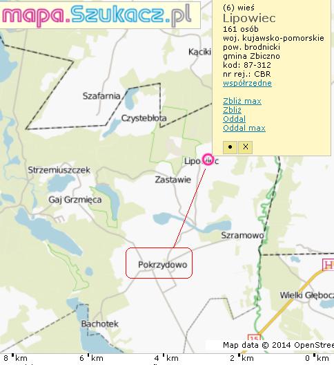
Posted: Mon Sep 22, 2014 5:43 pm
Post subject:
Felicia,
Map attached.
Records in
Archiwum Państwowe w Toruniu
87-100 Toruń, pl. Rapackiego 4
tel: (56) 622-47-54
fax: 621-01-29
email: [email protected]
www.torun.ap.gov.pl
However, they don't have birth records for 1895 in Pokryzdowo. Maybe you should ask them to search in Zbiczno.
Gilberto
| Description: |
|
| Filesize: |
38.93 KB |
| Viewed: |
15715 Time(s) |
|
|
|
|
Posted: Tue Sep 23, 2014 12:42 am
Post subject:
Gilberto,
Interesting map. Do you know what the dotted border is?
Thanks for the tip on Zbiczno.
Felicia
|
|
|
Posted: Tue Sep 23, 2014 7:44 am
Post subject:
| Feliciaj327 wrote: | Gilberto,
Interesting map. Do you know what the dotted border is?
Thanks for the tip on Zbiczno.
Felicia |
Felicia,
the darker one is the borderline between kujawsko-pomorskie and warminsko-mazurskie provinces; the lighter one is the borderline between Zbiczno and Brzoze gminas.
Gilberto
| Description: |
|
| Filesize: |
209.71 KB |
| Viewed: |
15715 Time(s) |
|
| Description: |
|
| Filesize: |
47.62 KB |
| Viewed: |
15715 Time(s) |
|
|
|
|
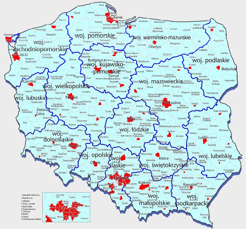
Posted: Wed Sep 24, 2014 4:45 pm
Post subject:
Gilberto,
Thanks so much! What you just posted is a great help! The mapa.szukacz.pl site I pulled up looks like it would be a great aide for finding other towns and cities. I was able to have the site translated to English. Do you know if there is such a map that shows the same type of information, but from the 19th century? I would love to be able to see where the borders were for the Prussian, Russian sections with the towns and cities shown. I hope there is such a map!
I'm sorry to be such a pest, but you have been able to come up with so much information I need and I hate to let you go!
Felicia
|
|
|
Posted: Thu Sep 25, 2014 1:40 am
Post subject:
Gilberto,
I am bowled over by all those links! It will take a while to delve into all the information provided. You are absolutely amazing! Thank you!
Felicia
|
|
|
dnowickiPO Top Contributor
Joined: 28 Dec 2011
Replies: 2950
Location: Michigan City, IndianaBack to top |
Posted: Thu Sep 25, 2014 8:58 am
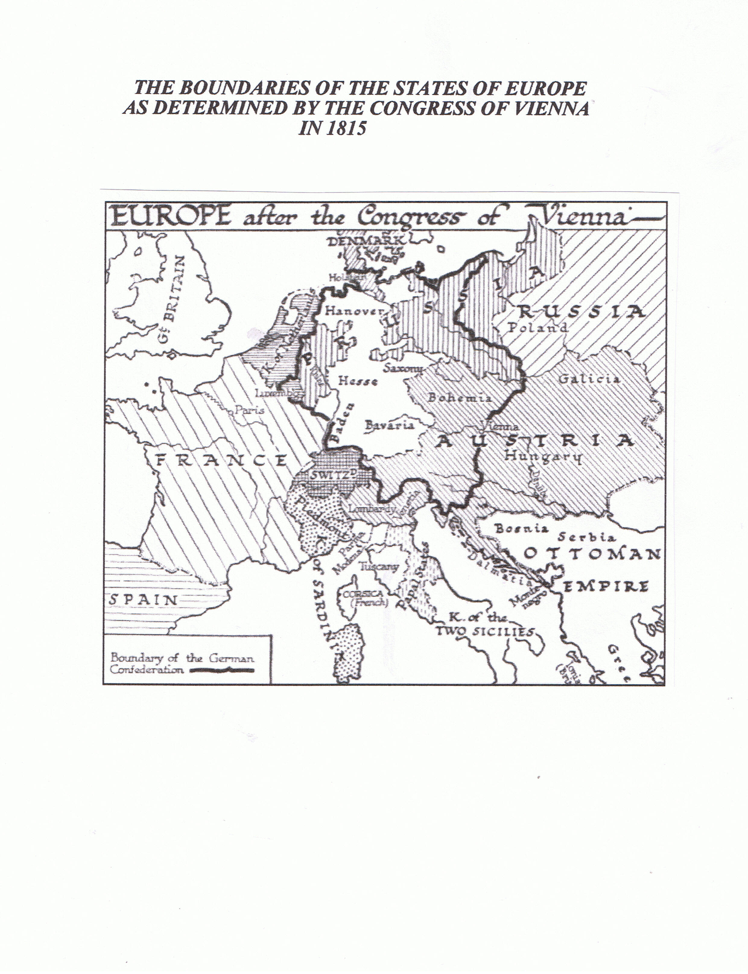
Post subject:
Felicia,
The late 18th Century and the early 19th Century was a time when the boundaries of the states of Europe were in flux. The boundaries of the lands of Poland taken by Prussia, Russia and Austria changed from what they were after the third partition in 1795. After the Congress of Vienna in 1815 the areas under the control of Prussia, Russia and Austria remained stable until WWI. The attachments are some maps which may help to those changes into perspective and give you a clearer picture of what you see on the maps Gilberto suggested. The map of the Commonwealth in the 17th Century shows the diversity of the territories of the old Polish-Lithuanian Commonwealth. Poland at the time was both a royal republic and a commonwealth. Poland was the predominant nation in the commonwealth. The country was known by various titles: The Republic of the Two Nations, The Polish-Lithuanian Commonwealth, The Most Serene Republic of Poland (The official diplomatic title usually found in the Latin form of Serenissima Respublica Poloniae), and simply Poland. On the map of the Commonwealth (Rzeczpostpolita w XVII w.) ziemie koronne shows the lands which were held by the crown and ziemie Wielkiego Ksiestwa Litewskiego shows the lands of the Grand Duchy of Lithuania. Those two territories made up most of the territory of the Commonwealth. The map of the Partitions of Poland shows the boundaries of the territories held by the partitioning nations in 1795. The Duchy of Warsaw map shows the territories taken from the partitioning powers during the Napoleonic Wars which Napoleon then set up as a state dependent on France. The map of Europe in 1815 shows the boundaries of the areas of Poland under the control of Russia, Prussia/Germany, and Austria after Napoleon's defeat, boundaries which endured until WWI.
Since there is a limit to the number of attachments allowed with each post. I'll attach more maps in a separate post.
Dave
| Description: |
|
| Filesize: |
807.19 KB |
| Viewed: |
15715 Time(s) |

|
| Description: |
|
| Filesize: |
666.56 KB |
| Viewed: |
15715 Time(s) |

|
| Description: |
|
| Filesize: |
639.66 KB |
| Viewed: |
15715 Time(s) |

|
| Description: |
|
| Filesize: |
831.96 KB |
| Viewed: |
15715 Time(s) |
|
|
|
|
dnowickiPO Top Contributor
Joined: 28 Dec 2011
Replies: 2950
Location: Michigan City, IndianaBack to top |
Posted: Thu Sep 25, 2014 9:08 am
Post subject:
Felicia,
German Poland was also known as the Province of Posen. I've not found a detailed map of that area which I really like. The two attached maps show the districts of that area with only larger cities and towns shown. (Ignore the names at the top of the page since that was a map I shared with one set of cousins and the names were meant to orient them.) The second map is more detailed but does not show the boundaries of the area.
Hope these maps help you bit.
Dave
| Description: |
|
| Filesize: |
986.33 KB |
| Viewed: |
15715 Time(s) |

|
| Description: |
|
| Filesize: |
678.68 KB |
| Viewed: |
15715 Time(s) |

|
|
|
|
|
|
|