jackiewisniewski

Joined: 01 Jan 2011
Replies: 51
Location: Riverside, IL., USABack to top |
 Posted: Wed Mar 18, 2015 3:06 pm
Post subject: Searching for the phantom village of Czerniaki
Posted: Wed Mar 18, 2015 3:06 pm
Post subject: Searching for the phantom village of Czerniaki
I would like to find out more about one of the villages my ancestors lived in, but I keep hitting road blocks. I had many, many Wisniewski ancestors living in a town called Czerniaki, part of Giewartow Parish, Powiat Slupca, in Wielkopolskie. Until today, the following record examples were the only place I could find the name of “Czerniaki” mentioned (this is just a small selection of the records):
http://szukajwarchiwach.pl/54/747/0/6.1/45/skan/full/Cc-9TDVroQ4M9I5ziBet-g (no. 60, birth)
http://szukajwarchiwach.pl/54/747/0/6.1/43/skan/full/qnl8EIiYVjHZYan6MeL4RA (no. 15, marriage)
http://szukajwarchiwach.pl/54/747/0/6.1/56/skan/full/q34RHSP9cXhXWZp1b3SABA (no. 12, marriage)
http://szukajwarchiwach.pl/54/747/0/6.1/43/skan/full/dj_F3eF6JFDmw4q8LfIBNA (no. 24, death)
I’ve searched the places database and forums here but the single result (Ulatowo Czerniaki) was not located near Giewartow Parish.
This week I searched the Slownik Geograficzny Krolestwa Polskiego I innych krajow slowianskich and found my first clue, as Czerniaki was found in the Holendry listing on p. 99 (Holendry-Czerniaki). Apparently it (and a few other villages listed) was located on the shores of Lake Powidzkie, on the border of Prussia, but on present-day maps the only Holendry town from that listing that is still there is Giewartow-Holendry. For the period of 1918-1945 I searched Skorowidz miejscowosci Rzeczypospolitej Polskiej but did not find it under Czerniaki or Holendry pages.
I’ve gone through countless historical maps at http://www.davidrumsey.com of the area, but this village has not appeared on any single map I’ve been able to find. I’ve also tried searching on http://igrek.amzp.pl/mapindex.php, and I’m pretty sure I’ve gone through every map between 1860-1921 that covered the Slupca/Konin/Poznan area to look for that town. I see lots of familiar towns, but have yet to come across Czerniaki/Holendry-Czerniaki anywhere near Giewartow or Lake Powidzkie. I had no luck on http://mapa.szukacz.pl either.
I’ve tried countless variations of word searches on google looking for sites with info on former polish villages, but with no luck. I’ve run exact searches for the village name, along with variations of it’s ending, and still have not come across anything more on this village.
Would anyone know how I can find out what happened to it? So far I’ve seen it in records dated from about 1860 through 1903. Can anyone suggest any other map resources or ideas on how to find out more about towns that no longer exist? Any help is appreciated. 
It does not appear to be a good sign that google translates Czerniaki into “melanoma” in English… 
Jackie
|
|
|
PolishLibrarianPO Top Contributor
Joined: 28 Aug 2010
Replies: 323
Back to top |
Posted: Wed Mar 18, 2015 3:53 pm
Post subject:
Jackie~ There's a village Czerniak (no i at the end) about 24 miles north of Giewartów, but considering the geography between the two villages/towns, it seems unlikely that this Czerniak would be in the Giewartów parish... ~PL
|
|
|
PolishLibrarianPO Top Contributor
Joined: 28 Aug 2010
Replies: 323
Back to top |
Posted: Wed Mar 18, 2015 7:20 pm
Post subject: Re: Searching for the phantom village of Czerniaki
| jackiewisniewski wrote: | I’ve searched the places database and forums here but the single result (Ulatowo Czerniaki) was not located near Giewartow Parish.
It does not appear to be a good sign that google translates Czerniaki into “melanoma” in English…
Jackie |
Prost~ It seems that Jackie has already eliminated that location. ~PL
|
|
|
dnowickiPO Top Contributor
Joined: 28 Dec 2011
Replies: 2956
Location: Michigan City, IndianaBack to top |
Posted: Wed Mar 18, 2015 7:48 pm
Post subject:
Jackie et al,
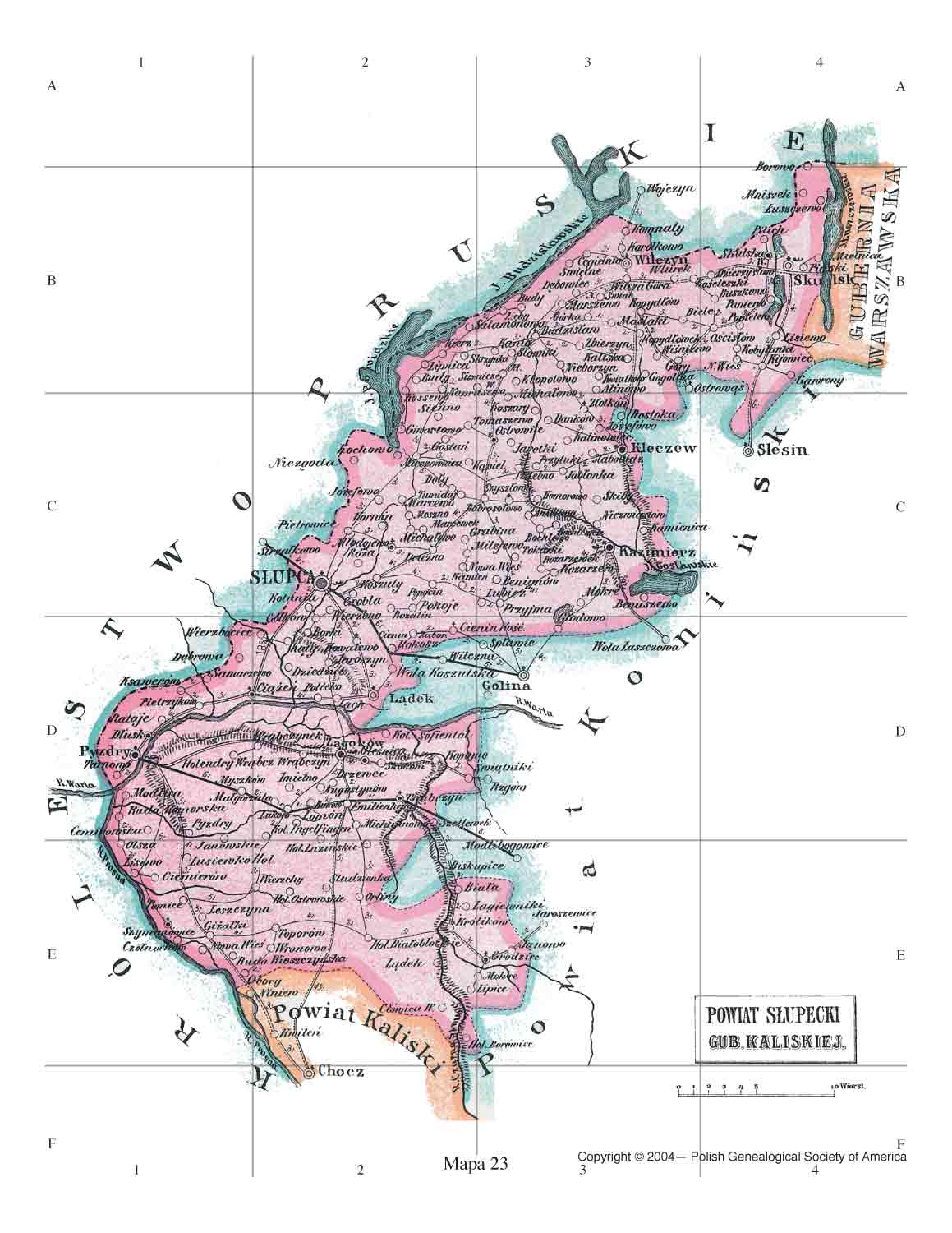
Since the Slownik entry lists six holendry along the shore of the lake (H. Giwartowskie, H. Czerniaki, H. Lipnica, H. Dolny, H. Brzoza, and H. Kockowskie) and since only the first appears on contemporary maps, it appears likely that the others were small and passed out of existence quite a while ago. Without locating a very detailed map of the are from the 19th Century it is unlikely that the exact location of these places can be determined. The Slownik entry states that these places were on the shore of the lake and the border between the Congress Kingdom and the German Partition (The Provence of Posen aka the Kingdom of Prussia). The attached map of the powiat of Slupca from the 1907 detailed map of the Congress Kingdom shows the border between the two partitions dividing the lake and all those Holendry would have located on the eastern shore of the lake. Unfortunately, none appear on the map. Given that Holendry were often small settlements for the raising of cattle they were probably not really villages, but simply "settlements" which have slipped into oblivion---not what you want to hear, but probably the reality of the situation.
Sorry that none of this helps to pin down the location of Holendry Czerniaki.
Dave
| Description: |
|
| Filesize: |
125.37 KB |
| Viewed: |
8772 Time(s) |
|
|
|
|
jackiewisniewski
Joined: 01 Jan 2011
Replies: 51
Location: Riverside, IL., USABack to top |
Posted: Wed Mar 18, 2015 8:14 pm
Post subject:
| dnowicki wrote: | Jackie et al,
Since the Slownik entry lists six holendry along the shore of the lake (H. Giwartowskie, H. Czerniaki, H. Lipnica, H. Dolny, H. Brzoza, and H. Kockowskie) and since only the first appears on contemporary maps, it appears likely that the others were small and passed out of existence quite a while ago. Without locating a very detailed map of the are from the 19th Century it is unlikely that the exact location of these places can be determined. The Slownik entry states that these places were on the shore of the lake and the border between the Congress Kingdom and the German Partition (The Provence of Posen aka the Kingdom of Prussia). The attached map of the powiat of Slupca from the 1907 detailed map of the Congress Kingdom shows the border between the two partitions dividing the lake and all those Holendry would have located on the eastern shore of the lake. Unfortunately, none appear on the map. Given that Holendry were often small settlements for the raising of cattle they were probably not really villages, but simply "settlements" which have slipped into oblivion---not what you want to hear, but probably the reality of the situation.
Sorry that none of this helps to pin down the location of Holendry Czerniaki.
Dave |
Thank you all for trying! I've been working on a migration map/timeline of sorts to track my ancestors movements and this is the first time I have a location that I cannot map.
Dave would you happen to know if, when establishing a settlement, whether paperwork would need to be filed with local officials? I assume that a group of people wouldn't have been allowed to settle in an unoccupied area and just decide what to call it, but with my luck lately I could be wrong! If paperwork was involved, that at least gives me hope that I may stumble across it in an archive in the future.
I am also still hoping to discover more resources for old maps for that region. One can never have too many maps.
Jackie
|
|
|
dnowickiPO Top Contributor
Joined: 28 Dec 2011
Replies: 2956
Location: Michigan City, IndianaBack to top |
Posted: Wed Mar 18, 2015 9:11 pm
Post subject:
Jackie,
I'm not sure about paperwork connected to new settlements being filed but my instinct is that there were no plats drawn up and probably no paperwork filed. From what I've seen, new settlements (Holendry, Budy, etc. often were named using the surname of the landowner where the new settlement was located. I don't think that a group of people could just "squat" on the land. Rather, I believe the landowner was interested in making his estate more productive so he invited individuals to settle in a given location on the estate. It would require specific research to learn how the settlements were structured and what incentives were used to attract settlers but my instinct is that whatever was done was done by the landowner according to his wishes with little or no regulations imposed by the political authorities in the area.
Although all my ancestors are Polish my nephew (my brother's son) asked me to do the same kind of genealogical research for his little daughter as I had done for our Polish relatives. My late sister-in-law had some German ancestry and when I started to research her ancestors I learned that they were Germans from Russia aka Volga Germans. The Czarina Katherine the Great (from the Russian point of view) or Katherine the Great Land-grabber (from the Polish point of view) was of German ancestry and during the last quarter of the 18th Century invited Germans to settle in the wild and wide open areas along the Volga River. To make the idea attractive she offered a number of perks to the settlers and as a result a substantial number of German colonies grew up in the area. These colonies maintained their German language, culture, etc. and many survived until the mid 20th Century i.e. until WWII. It appears that these colonies never assimilated into the mainstream Russian culture and it also appears that for the first 100 years or so they were not bothered by a lot of government regulations. My instinct is that new settlements in Polish lands were somewhat analogous in the sense that the major landowners were free to do what they pleased with their land in terms of settlements. The two situations also seem analogous in the sense that the place names no longer exist. Although the attached maps of the German Volga villages are not directly related to your quest I though that they are worth posting as examples of how settlements can be established and flourish and then disappear.
Hope the answer helps a bit and that you find the Volga German digression interesting although it is not exactly on point.
Dave
| Description: |
|
| Filesize: |
314.39 KB |
| Viewed: |
8772 Time(s) |

|
| Description: |
|
| Filesize: |
406.01 KB |
| Viewed: |
8772 Time(s) |

|
|
|
|
jackiewisniewski
Joined: 01 Jan 2011
Replies: 51
Location: Riverside, IL., USABack to top |
Posted: Thu Mar 19, 2015 7:24 am
Post subject:
| dnowicki wrote: | Jackie,
I'm not sure about paperwork connected to new settlements being filed but my instinct is that there were no plats drawn up and probably no paperwork filed. From what I've seen, new settlements (Holendry, Budy, etc. often were named using the surname of the landowner where the new settlement was located. I don't think that a group of people could just "squat" on the land. Rather, I believe the landowner was interested in making his estate more productive so he invited individuals to settle in a given location on the estate. It would require specific research to learn how the settlements were structured and what incentives were used to attract settlers but my instinct is that whatever was done was done by the landowner according to his wishes with little or no regulations imposed by the political authorities in the area.
Although all my ancestors are Polish my nephew (my brother's son) asked me to do the same kind of genealogical research for his little daughter as I had done for our Polish relatives. My late sister-in-law had some German ancestry and when I started to research her ancestors I learned that they were Germans from Russia aka Volga Germans. The Czarina Katherine the Great (from the Russian point of view) or Katherine the Great Land-grabber (from the Polish point of view) was of German ancestry and during the last quarter of the 18th Century invited Germans to settle in the wild and wide open areas along the Volga River. To make the idea attractive she offered a number of perks to the settlers and as a result a substantial number of German colonies grew up in the area. These colonies maintained their German language, culture, etc. and many survived until the mid 20th Century i.e. until WWII. It appears that these colonies never assimilated into the mainstream Russian culture and it also appears that for the first 100 years or so they were not bothered by a lot of government regulations. My instinct is that new settlements in Polish lands were somewhat analogous in the sense that the major landowners were free to do what they pleased with their land in terms of settlements. The two situations also seem analogous in the sense that the place names no longer exist. Although the attached maps of the German Volga villages are not directly related to your quest I though that they are worth posting as examples of how settlements can be established and flourish and then disappear.
Hope the answer helps a bit and that you find the Volga German digression interesting although it is not exactly on point.
Dave |
Thank you again Dave, the Volga German maps are quite interesting! I sort of smacked myself in the forehead after reading your post, hopefully after having done a few more years of research in Poland I won't easily forget how things worked out there, with the landowners and peasants. Sort of a big deal to have overlooked, especially since most of my ancestors from this area were not land owners - I don't know WHAT made me think they could squat and create a settlement! 
Jackie
|
|
|
|
|
|